by Merdi Jean Arcilla
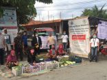
In photo: Typhoon tracking exercise at the Community-Based Early Warning System Training in Barangay Potrero, Malabon City
"If you want to develop your barangay early warning system for floods, it should be taken in the context of the Tullahan River basin” was the expert piece of advice that Susan Espinueva gave to the group that was seeking PAGASA’s technical assistance. That was in July 2013.
by Merdi Jean Arcilla
In photo: Typhoon tracking exercise at the Community-Based Early Warning System Training in Barangay Potrero, Malabon City
"If you want to develop your barangay early warning system for floods, it should be taken in the context of the Tullahan River basin” was the expert piece of advice that Susan Espinueva gave to the group that was seeking PAGASA’s technical assistance. That was in July 2013.
Ms. Espinueva was then Chief of the Hydrometeorology Division of PAGASA. Barangay Potrero in Malabon City was planning to improve its early warning system (EWS) as part of enhancing the community’s preparedness, and the Partners for Resilience program was keen on providing ample support.
Potrero is downstream of Tullahan River
Rain or shine, there are floods in Malabon. News on television has frequently shown Malabon with above ankle-deep flood water due to high tides even during clear skies and good weather. During the typhoon and monsoon rains, of course the situation worsens considerably.
In 2009 during Typhoon Ondoy (Ketsana), residents of Barangay Potrero in Malabon were startled that the water kept rising faster than normal and eventually reached the second floor of some homes. Some 6,000 families were affected. Some of these were trapped inside structures, in need of rescue support and emergency provisions. Three years later in August 2012, the same communities were again affected by floods due to heavy monsoon rains that lasted for several days.
The largest of Malabon’s 21 barangays is Potrero. With a population of around 54,000, it has been one of the most affected by the worst floods in the city. Sections of the barangay lie along the downstream of Tullahan River that stretches from Quezon City to Valenzuela City. Runoff starting from upstream La Mesa Dam in Quezon City, heavily silted and clogged Tullahan River and the frequent occurrence of high tides further contribute to the frequent floods in the area.
Potrero is one of the seven urban barangays where the Partners for Resilience (PfR) has been operating the program since 2011. It was specifically chosen because it is susceptible to floods and the affected populations mostly belong to the urban poor. The PfR program engages the Potrero barangay local government to enhance its preparedness for emergency response and work towards disaster risk reduction incorporating climate change and ecosystems management and restoration.
The road to September 2013
In the ensuing discussions with PAGASA, the group settled that to work on the EWS of Potrero it has to deal with the current status of EWS for floods in the river basin and the affected stakeholders. The Tullahan River basin covers Quezon City and the CAMANAVA area – the cities of Caloocan, Malabon, Navotas and Valenzuela. All five cities contend with the problem of floods especially in the communities that lie along or are near the Tullahan River and its waterways.
While each has ways and actions to manage the risk, the general picture is that they do not necessarily link together to address the problem. There are EWS facilities that line the river at different points. These are basically water level and rain gauges. The La Mesa Dam Authority notifies LGUs and the public on the level of dam water. PAGASA consolidates the information that is generated from some of the EWS facilities and can make these available to LGUs. Pumping stations, river walls, dikes and other protective structures have been built in selected areas to protect specific segments of areas that are high-risk to floods. Each city issues alerts and warning based on information they are able to access.
“The floods are a problem caused by several factors in the river basin. Why don’t we call a meeting of the cities, concerned agencies and other groups who have a stake in drawing up solutions?” Once again, Susan Espinueva was forwarding sound guidance.
In September 2013, PAGASA and PFR spearheaded the first meeting of stakeholders to discuss issues on EWS for Quezon City and CAMANAVA. PAGASA defined the scope of the Tullahan River basin and traced the flow of floodwaters from upstream passing through the five cities and exiting at Manila Bay. It also showed the existing facilities for drawing up the river basin-wide EWS and pointed out that the work still has to be done to have an integrated EWS for the whole river basin. And this needs the participation of the various stakeholders.
The LGUs attended, all represented by their DRRMOs. Other agencies like the MMDA, DILG-NCR which issues the guidelines for the DRRM plans of LGUs in Metro Manila, NDRRMC which manages a big DRR project for UNDP, Ipo and La Mesa Dam authorities participated to share how they were contributing to the provision of information and shared experiences relating to flood risk management. The meeting ended on a positive note that the discussions would continue towards harmonizing the EWS for the Tullahan River basin.
The partnership gains momentum
The partners’ initial step was to survey the long stretch of Tullahan River, and see the river situation and the existing EWS facilities. In the debriefing, each partner also shared how they are doing flood mitigation measures through projects and programs within their geographical boundaries. The group also visited the Pampanga Flood Forecasting and Warning System to look at a model of an integrated EWS for a river basin that gathers information, processes this and issues warnings based on the result of the data analysis.
One of the good insights that came out of these activities is that the participants themselves appreciate the continuing dialogues. They even proposed that for purposes of continuity and understanding, the same individuals be officially assigned to sit in these coordination meetings. The most recent gathering they took part in was the presentation of the results of the risk assessment covering the whole Tullahan River basin. They expressed that information sharing that serves to enrich their basis of risk reduction actions is very much needed.
For Malabon and Valenzuela, a step further was taken when they concurred and got involved in the tree planting in the upstream La Mesa Watershed. The location is beyond their geographical boundaries and yet they recognize that this is a mitigation action that will definitely benefit their communities in terms of improved urban forest cover and protected watershed or source of water for the metropolis residents.
Moving forward
“Let us look at other organized groups of LGUs who have the good practice of working together to reduce the risk of floods and other hazards and learn from them,” was the common call in the last gathering of these stakeholders in September 2014. It was a year after the initial meeting of stakeholders in the Tullahan river basin. The risk assessment was done by a group composed of individuals knowledgeable in history, biology and environmental science. More and more, they are convinced that they need multi partnerships and multi disciplines to proceed with a good analysis of the risk situation they are facing and hence need the same methods to forward an integrated plan or solutions to pursue in their next steps.